AMICUS and ARTEMIS are two projects focused on the Amundsen Sea, Antarctica. The former is funded by NASA and led by S.Stammerjohn at U.Colorado, while the latter is funded by NSF and led by P.Yager at UGA. Any opinions, findings, and conclusions or recommendations expressed in this material are those of the author(s) and do not necessarily reflect the views of NASA or the National Science Foundation.
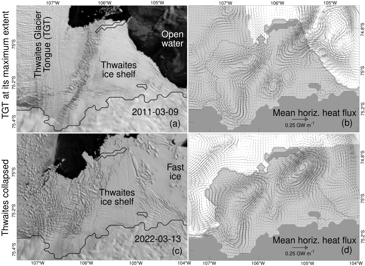
Figure 1: Response of onshore oceanic heat supply to changes in the Amundsen Sea icescape, Antarctica. (a) Thwaites Glacier Tongue (TGT) at its maximum geographical extent (satellite image of March 2011, from Scambos et al. 2022). (b) Corresponding distribution of oceanic heat flux fueling the melt of Thwaites. (c) Same as a) but with the TGT collapsed and a fast-ice cover east of Thwaites (March 2022). (d) Same as b) but illustrating the profound circulation changes caused by the TGT collapse and the fast-ice cover. Thwaites is a key part of the “weak underbelly” (Hugues 1981) owing to its role in potential collapses of the west Antarctic Ice Sheet. See our presentation at the Ocean Science Meeting and this publication.
Figure 2: Simulated surface geostrophic velocity on the continental shelf of the Amundsen Sea in austral summer 2022. For best results, download the video (.mp4) onto your device and play it from there. The black areas are the coast of west Antarctica while the dark gray line indicates the shelf break. North is upward in the figure. Note the increasingly eddying flow through the course of the summer as sea ice and the friction against it subside. (Heavy sea ice conditions persist throughout the summer in the northern half of the Eastern Trough.) Mesoscale eddies on the continental shelf have small diameters 20–30 km owing to the weak vertical stratification (see the scale in the video.) Continental shelf eddies are only captured in models of fine resolution and low-diffusivity numerics such as this one.
Figure 3: Simulated glacial meltwater concentrations on the continental shelf of the Amundsen Sea at 200 m depth in austral summer 2022. For best results, download the video (.mp4) onto your device and play it from there. The black areas represent the coast of west Antarctica and north is upward in the figure. Glacial meltwater is estimated from modeled salinity and potential temperature assuming fixed water mass characteristics for modified Circumpolar Deep Water, Winter Water, and glacial ice. These water mass characteristics are representative of the Dotson Trough, specifically, (see Supplementary Table 2 of Jenkins et al., 2018) and therefore meltwater concentrations obtained from that method are increasingly inaccurate away from Dotson Trough. Values off the continental shelf are thus masked (black) in the videos. Note that Jenkin's method also becomes increasingly inaccurate above 200 m depth (see Kim et al. 2016 for a comparison with noble gases) which is why the video focuses on that depth horizon.
Figure 4: Simulated potential temperature of modified Circumpolar Deep Water (mCDW) on the continental shelf of the Amundsen Sea in austral summer 2022. For best results, download the video (.mp4) onto your device and play it from there. The black areas are the coast of west Antarctica, the upper dark gray line indicates the shelf break, and the lower dark gray lines indicate the front of the ice shelves (and tabular iceberg B22). North is upward in the figure. mCDW temperature is here defined as the maximum temperature registered below 100 m depth. The pathways of mCDW on the continental shelf are described in Dutrieux et al. 2014 (Eastern Trough), Kim et al. 2021 (Dotson Trough), Assmann et al. 2019 (Siple Trough).
Figure 5: Simulated surface conditions on the continental shelf of the Amundsen Sea in austral summer 2022. For best results, download the video (.mp4) onto your device and play it from there. The black areas are the coast of west Antarctica, dark gray are ice shelves, and white is sea ice. North is upward in the figure. The sea surface temperature (SST) is shown in regions of open water (i.e., where sea ice concentration is < 15%). The opening at the center of the figure is the Amundsen Sea Polynya (ASP). Note the periodic opening/closing of leads along the shelf break caused by the diurnal tidal currents that are most vigorous there (see Jourdain et al. 2019 to learn more about tides in this region).
Antarctica's floating glacial ice shelves are focal points for grounded ice sheet export through calving and basal ice shelf melt. In the Amundsen Sea Embayment (ASE) there have been accelerated glacial losses, thinning of ice shelves, and grounding line retreats driven in large part by changes in the atmospheric and ocean circulation that in turn drive changes in the delivery of warm modified Circumpolar Deep Water to ice shelf cavities and grounding lines. The marine ice cover (inclusive of seasonal and multiyear sea ice, fast ice, and grounded and drifting icebergs) plays a modulating but poorly understood role. In the ASE, the marine ice cover is also punctuated by the Pine Island and Amundsen Sea polynyas, two highly productive sea ice areas that are separated and heavily influenced by the varying extent of Thwaites Glacier, Iceberg and Fast ice tongue (TGIF). While it has been shown that the marine ice cover plays an important buttressing role in the stability of Antarctic ice shelves, it is certain (though not yet fully quantified) that the marine ice cover in the ASE also modulates ocean circulation and ocean heat delivery to ice shelf cavities. If we are to understand and better predict drivers of Antarctica’s ice sheet changes and consequent effects on sea-level, then we require better understanding of how the marine ice cover serves as a critical boundary and external driver of ice shelf changes. With improved remote sensing capabilities and high-resolution (1.5 km) coupled sea ice/ocean/ice shelf numerical modeling, we aim to investigate how local and regional changes in sea ice production and the marine ice cover, including changes in the TGIF and its adjacent polynyas, affect ocean heat delivery to ASE ice shelf cavities. This analysis will rely on a suite of multi-sensor multi-year satellite data comprising high-resolution optical (MODIS, WorldView) and synthetic aperture radar (SAR; Sentinel-1 and Radarsat Constellation, as available) imagery for characterizing fine-scale features of the marine ice cover, including also sea ice drift (SSM/I, AMSRE/2, Sentinel, Envisat) and estimates of sea ice thickness (ICESat, ICESat-2, Cryosat-2, and IceBridge). This detailed information will then be used to analyze the role of the marine sea ice cover and sea ice production in driving variability in the upper ocean and will include both local and regional scale analysis of polynya sea ice production, sea ice growth/melt at the advancing/retreating ice edge, and deformation-driven sea ice production within the existing pack ice. These processes that link the ocean and marine ice cover will be further investigated in a suite of model experiments designed to highlight the role and impacts of different surface forcing and marine ice states as imposed by climate variability and change. These experiments address changes in: the configuration of the TGIF, amount and thickness of sea ice imported into the eastern Amundsen Sea, atmospheric temperatures and winds, and oceanic temperatures off-shelf. Given what we learn from the data-model analysis about the coupled system under different modes of sea ice-climate variability, we can then apply that knowledge to the 40-year sea ice record (AMSRE/2 and SMMR-SSM/I-SSMIS) to give us information and insights on how marine ice cover variability may have modulated ocean-ice shelf interactions in the past, and how it will continue to do so in the future. Significance to the Objectives of the Solicitation and NASA: This project seeks to understand the physical linkages between three rapidly changing components of the cryosphere—the Antarctic marine ice cover, the underlying ocean, and the abutting ice shelves—to better understand the future fate of Antarctica’s ice shelves (and marine-grounded ice sheet) in a changing climate. This is achieved using a suite of remotely sensed data, modeling, and data-model analysis.
Research cruise: The TARSAN-ARTEMIS-THOR expedition took place in early 2022. The research icebreaker Nathaniel B. Palmer sampled the Amundsen Sea using ship-board instruments, gliders, and instrumented seals. The expedition documented their work on twitter and instagram.
Figure 6: Interactive map of modeled results before/after the ARTEMIS cruise, 1 December 2021 to 1 March 2022. Orient your mobile device landscape for best results and use the top-right button to switch between layers.
Video: Sea ice conditions, winds and cruise track during the ARTEMIS cruise. Download the video and play it on your device for best results. The daily sea ice concentration is from University of Bremen. Arrows are daily winds from ERA5.
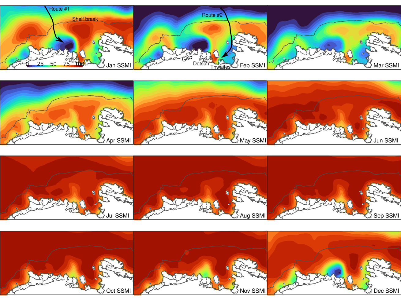
Figure 7: Climatology of sea ice concentrations in the Amundsen Sea. The climatology is from SSMI (satellites) and representative of the 1st day of the month (January 1, February 1, etc.) over the past 15 years (2006–2020). Dark red indicates heavy sea ice conditions (100% coverage) while black indicates ice free conditions (0%). The North is upward in this map projection and the ice shelves of interest (Thwaites, Dotson, Getz) are labeled in the February figure. The two arrows (see January and February) indicate common routes used by icebreakers to access the continental shelf during the austral summer (Jan.–Feb.) while avoiding areas of heavy sea ice.
Overview of ARTEMIS project: The Amundsen Sea hosts the most productive polynya in all of Antarctica, with its vibrant green waters visible from space, and an atmospheric CO2 uptake density 10x higher than the Southern Ocean average. The region is vulnerable to climate change, experiencing rapid losses in sea ice, a changing icescape, and some of the fastest melting glaciers flowing from the West Antarctic Ice Sheet (WAIS). ARTEMIS aims to characterize the climate-sensitive nature of glacial meltwater-driven micronutrient (iron, Fe) contributions driving ecosystem productivity and CO2 uptake in the coastal Antarctic. We propose to integrate observations and ocean modeling of these processes to enhance predictive capabilities. Currently, basal melt resulting from warm deep waters penetrating ice shelf cavities dominates mass losses of WAIS, contributing to sea level rise. These physical melting processes are being studied by the International Thwaites Glacier Collaboration (ITGC). The impact of melting on the marine ecosystem has also been explored, and we know that productivity is due in part to Fe-rich, glacial meltwater-driven outflow. The biogeochemical composition of the outflow from the glaciers surrounding the Amundsen Sea is largely unstudied, however. Improved knowledge would provide keys to understanding meltwater's future impact on the ecosystem. An ongoing field program (TARSAN, part of the ITGC) offers the ideal physical oceanographic framework for our biogeochemical effort. We propose here to collaborate with TARSAN-supported UK scientists, providing value added to both team efforts. ARTEMIS would add shipboard measurements (trace metals, carbonate system, nutrients, organic matter, microorganisms) and biogeochemical sensors on autonomous vehicles to gather critical knowledge needed to understand the impact of the melting WAIS on both the coastal ecosystem and the regional carbon (C) cycle. Driving questions include: 1) what are the fluxes and chemical forms of Fe, C, and microorganisms in the ice shelf outflow? 2) what are the relative contributions to the ouflow from deep water, benthic, and glacial melt sources, and how do these inputs combine to affect the bioavailability of Fe? 3) How are Fe and C compounds modified as the outflow advects along the coastal current and mixes into the bloom region? and 4) what will be the effect of increased glacial melting, changes in the coastal icescape, and declining sea ice on the ecosystem of the Amundsen Sea? Such questions fall outside the focus of the ITGC, but are of keen interest to Antarctic Organisms and Ecosystems and Antarctic Integrated System Science programs.
Intellectual Merit: The magnitude and direction of the Southern Ocean CO2 flux is important to both the global carbon cycle and any potential feedbacks to climate change. This project explores the climate sensitive nature of a carbon cycle 'hot spot' in coastal Antarctica. Within the ideal physical framework provided by TARSAN, our process-oriented biogeochemical measurements will lead to better understanding of what the future holds for this important coastal ecosystem. In the rapidly changing ice sheet and sea ice environment, mapping chemical concentrations alone would be insufficient. By collaborating with UK scientists already using advanced physical oceanographic instrumentation on TARSAN, we will be able to 1) bridge the gap between biogeochemistry and physics: estimating fluxes and transport of limiting micronutrients; 2) provide biogeochemical context to broaden our understanding of the global significance of ocean-ice shelf interactions; 3) determine processes and scales of variability in micronutrient supply that drive the 10x increase in CO2 uptake, and 4) identify small-scale processes key to Fe and C cycling using optimized field sampling. Knowledge gained will help consider future impacts on the region and determine whether the climate sensitivity of the Amundsen Sea ecosystem represents the front line of processes generalizable to the greater Antarctic.
Broader Impacts: Melting ice sheets and their effect on sea level have captured the public's attention about climate change, and we take advantage of this to promote Antarctic ecosystem science through meaningful out-of-school science experiences for middle and high schoolers and a collaboration with undergraduate photojournalism students. We will also help educate the next generation of polar scientists: undergraduate, graduate, post-doctoral, and early-career. Model results will help enhance funded ITGC efforts, and model improvements will be available to the WAIS community, including scientists using marine paleoproxies for glacial melt. Our findings will be available to others through peer-reviewed publications, public databases, and a website. This proposal requires fieldwork in the Antarctic.